Trekking I: Gangotri-Nandanvan Trek
This trek route is for
adventure lovers, who can experience mountain climbing, rock climbing, 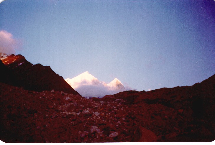 boulder-hopping and glacier traversing on this trek. Yet the trek is not
a very rigorous one and is easily negotiable by healthy persons who are
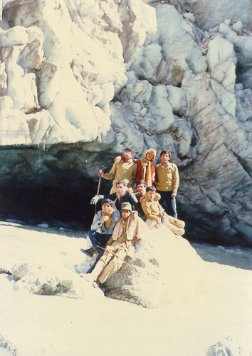
not mountaineers. It was in 1987 October. A large group of 30 NCC
cadets from I.I.T. Kanpur were going for Gaumukh-Nandanvan trek.
I was one of them. We reached Haridwar and hired a bus for Gangotri.
Haridwar and Rishikesh are gateway to the Garhwal Himalayas.
boulder-hopping and glacier traversing on this trek. Yet the trek is not
a very rigorous one and is easily negotiable by healthy persons who are
not mountaineers. It was in 1987 October. A large group of 30 NCC
cadets from I.I.T. Kanpur were going for Gaumukh-Nandanvan trek.
I was one of them. We reached Haridwar and hired a bus for Gangotri.
Haridwar and Rishikesh are gateway to the Garhwal Himalayas.
Some of the photographs added in this page are courtesy Alok Sharan. Alok had taken these snaps on his high altitude trek from Gangotri to Badrinath via Kalindi pass. That was in year 1994.
We took our first
 night halt at Tehri and started for Gangotri early next morning. Travelling
along river Bhagirathi, passing Uttarkasi on way, we reached Gangotri in
the evening. The mountain slopes on lower altitude are mostly barren as
a result of deforestation. But as we gained height, the road winded through
the dense pine and juniper forests. From Dharsu, the road bifurcates for
Yamunotri. Enroute we passed a hot water spring at Tatopani. Around Mala
we came across Apple Orchards.
night halt at Tehri and started for Gangotri early next morning. Travelling
along river Bhagirathi, passing Uttarkasi on way, we reached Gangotri in
the evening. The mountain slopes on lower altitude are mostly barren as
a result of deforestation. But as we gained height, the road winded through
the dense pine and juniper forests. From Dharsu, the road bifurcates for
Yamunotri. Enroute we passed a hot water spring at Tatopani. Around Mala
we came across Apple Orchards.
Gangotri is
a small village 250 kms from Rishikesh, and at an altitude of 3048m above
the sea level. Here river Bhagirathi rushes down the gorge. It is a major
pilgrimage for Hindus. It is said that Goddess Ganga was sent to earth
by Lord Shiva. It is at Gangotri that she descended on earth. The river
was named after King Bhagirath who was instrumental in getting Ganga to
the earth as a boon from Lord Shiva. Hence the name Bhagirathi. We stayed
 at Gangotri for the night. We had to arrange for guides and porters
for trek beyond Gaumukh. It was here only that we came to know about Gaumukh
Glacier having cracked thus making it a risky affair to go beyond Gaumukh.
For going till Gaumukh one doesn't require a guide. One will find number
of pilgrims on this route.
at Gangotri for the night. We had to arrange for guides and porters
for trek beyond Gaumukh. It was here only that we came to know about Gaumukh
Glacier having cracked thus making it a risky affair to go beyond Gaumukh.
For going till Gaumukh one doesn't require a guide. One will find number
of pilgrims on this route.
Next morning, carrying our backpacks, we started for Bhojbasa. This was my first trek and I was highly excited about it. Initially it was a gradual climb, occasionaly becoming steeper. My father had told me that one should take longer steps at slower pace when trekking. This maintains the pace without over exerting the body. Most of the route is devoid of any tree cover except for some coniferous pines at Chirbasa. We were anyway above the tree line. One encounters number of streams, formed by melting of snow at higher heights, on way to Gaumukh. Hence water is not a problem on this route.
Chirbasa is
 the first tea stall enroute to Bhojbasa. At an altitude of 3600 m,
it is 8 kms from Gangotri. After a gradual climb for 3 kms,
one goes downhill for last one km to reach Bhojbasa. One can camp
here or stay with Sadhus in their ashram. We reached Bhojbasa around 12
noon after covering 12 kms from Gangotri in 4 hours. Silver birch
or Bojpatra is the only vegetation in this region.
the first tea stall enroute to Bhojbasa. At an altitude of 3600 m,
it is 8 kms from Gangotri. After a gradual climb for 3 kms,
one goes downhill for last one km to reach Bhojbasa. One can camp
here or stay with Sadhus in their ashram. We reached Bhojbasa around 12
noon after covering 12 kms from Gangotri in 4 hours. Silver birch
or Bojpatra is the only vegetation in this region.
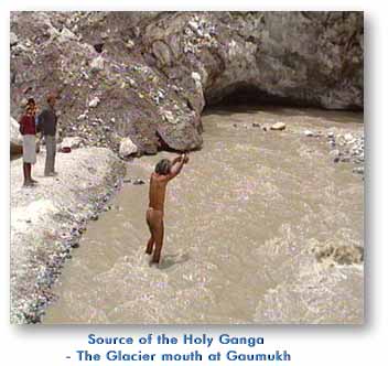
Gaumukh Galcier
is another six kms from Bhojbasa. After resting for an hour and allowing
 for others to join us, we started for Gaumukh. Initial one km is
steep climb after which one gradually gains altitude. The Glaciers ends
in a cave which resembles a cow's mouth, hence the name Gaumukh.
One can see the ice blocks breaking from the glacier and falling into the
river gushing out of the cave. The 40 km long Gangotri Glacier has a total
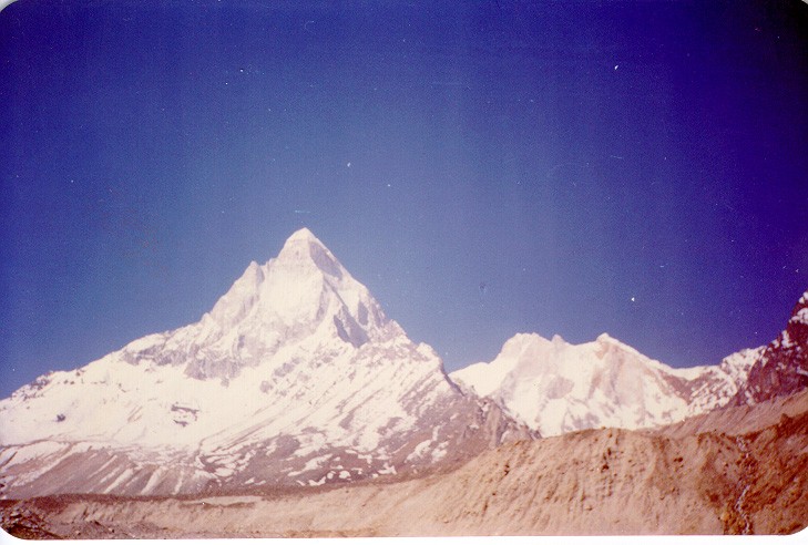
volume of almost 20 cubic kms of ice. From here one gets a good view of
Bhagirathi peaks, Bhagirathi I, II and III. With the last rays of setting
sun falling on the snow covered peaks, the view was majestic.
for others to join us, we started for Gaumukh. Initial one km is
steep climb after which one gradually gains altitude. The Glaciers ends
in a cave which resembles a cow's mouth, hence the name Gaumukh.
One can see the ice blocks breaking from the glacier and falling into the
river gushing out of the cave. The 40 km long Gangotri Glacier has a total
volume of almost 20 cubic kms of ice. From here one gets a good view of
Bhagirathi peaks, Bhagirathi I, II and III. With the last rays of setting
sun falling on the snow covered peaks, the view was majestic.
We took bath
right in front of the cave. Water was biting cold and no one was able to
 stay in water for more than few minutes. Blocks of ice rushed past us.
We were shielded by a boulder near the bank. By the time we turned back
for Bhojwasa, it was already dark. In the night, most of us who had taken
bath in the river, were feeling feverish. The night halt at Muni's
ashram in Bhojbasa was comfortable. Next morning we started back for Gangotri.
stay in water for more than few minutes. Blocks of ice rushed past us.
We were shielded by a boulder near the bank. By the time we turned back
for Bhojwasa, it was already dark. In the night, most of us who had taken
bath in the river, were feeling feverish. The night halt at Muni's
ashram in Bhojbasa was comfortable. Next morning we started back for Gangotri.
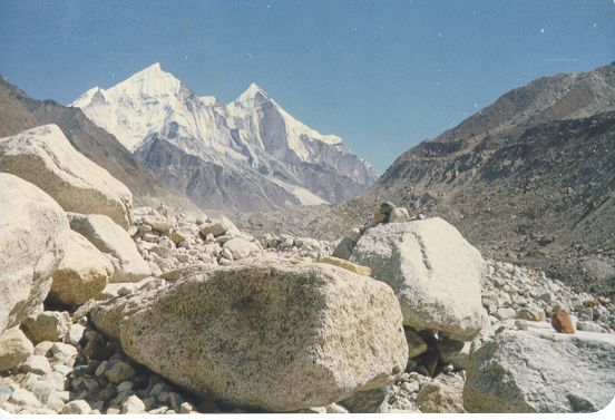
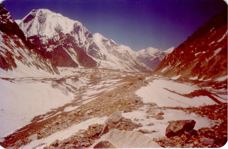
Nandanvan is
6 kms from Gaumukh and Tapovan is another 5 kms. From Gaumukh to Nandanvan,
trekkers traverse along the Gangotri and Chatturangini Glaciers. Camp can
be pitched at the junction of Chatturangini and Bhagirathi Gangotri
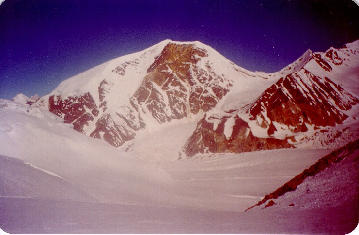
Glaciers. From Nandanvan the view of Shivling, Bhagirathi, Sudarshana and
Thelu peaks and Kedar Dome are a fabulous sight. The trek to Tapoban from
 Nandanvan involves crossing the Gangotri Glacier and traversing a rocky
face befor arriving at the meadows of Tapoban (meditating ground), a green
lush valley in the summers confined by the many named and unnamed peaks
of the Garhwal Himalaya. Herds of Bharals (blue mountain goats) are a common
sight seen on mountain ridges from here.
Nandanvan involves crossing the Gangotri Glacier and traversing a rocky
face befor arriving at the meadows of Tapoban (meditating ground), a green
lush valley in the summers confined by the many named and unnamed peaks
of the Garhwal Himalaya. Herds of Bharals (blue mountain goats) are a common
sight seen on mountain ridges from here.
For the more
adventerous, and with the fundamental knowledge of the mountains, an extension
of the Nandanvan trek eastward to Ghastoli and from there to Badrinath
via Kalindi Pass (5967 m) and Arwa Tal provides a rare experience. It involves
high altitude trekking and so preparations need to be made on a small expedition
 scale.
The trek is
from Nandanvan to Vasuki Tal after due acclimatization. It is a gradual
ascent for 10 kms. Thereafter, the trek negotiates Khara-pathar at a height
of 5456 m before camp is made at Kalindi base (5590 m). Crossing Kalindi
Pass very early in the morning, the trek leads to Arwa Glacier and Arwa
Tal (3980 m), then to Badrinath via Ghastoli with two river crossings on
the way.