TREKKING II: PINDARI & KAFNI GLACIERS
This
 article provides information about trek to Pindari and
Kafni Glaciers. By giving the first hand account, our intention
is to share the experience which will help fellow trekkers in their ventures.
Anybody can trek, provided they are able to match their experience to the
difficulty of the journey they plan. Pindari Trek is called beginners trek,
but it has all the ingradients of a good trek in a majestic Himalayan valley.
This route requires minimum preparation and one just needs a rucksack,
a sleeping bag, three sets of clothes and warm clothing. Any kind of sport
shoe with good grip will suffice for this trek provided they have been
worn before to avoid blisters. Sleeping bag and rucksack can be hired from
NTMC Nainital, or Kumauon Mandal Vikas Nigam (KMVN) rest house at Bageshwar.
Few days of exercising before leaving for trek, will tone up the body for
the adventure. KMVN rest house at every 10 kms saves you from worries regarding
accomodation on this route.
article provides information about trek to Pindari and
Kafni Glaciers. By giving the first hand account, our intention
is to share the experience which will help fellow trekkers in their ventures.
Anybody can trek, provided they are able to match their experience to the
difficulty of the journey they plan. Pindari Trek is called beginners trek,
but it has all the ingradients of a good trek in a majestic Himalayan valley.
This route requires minimum preparation and one just needs a rucksack,
a sleeping bag, three sets of clothes and warm clothing. Any kind of sport
shoe with good grip will suffice for this trek provided they have been
worn before to avoid blisters. Sleeping bag and rucksack can be hired from
NTMC Nainital, or Kumauon Mandal Vikas Nigam (KMVN) rest house at Bageshwar.
Few days of exercising before leaving for trek, will tone up the body for
the adventure. KMVN rest house at every 10 kms saves you from worries regarding
accomodation on this route.
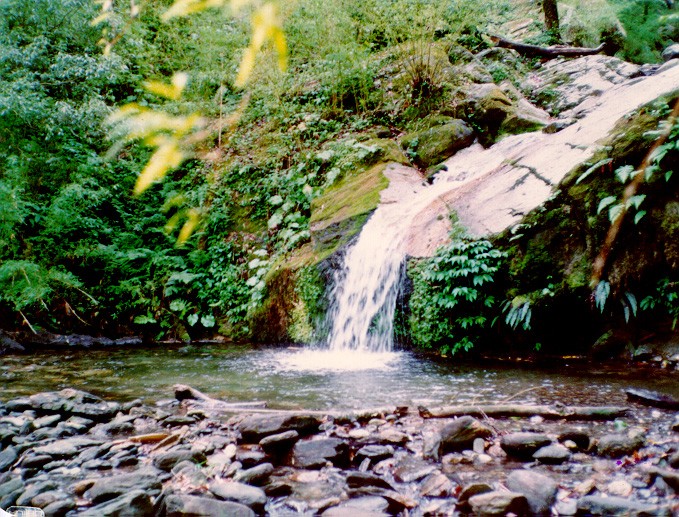
We had decided to tone our bodies for the rigours of
 the treks by trekking around Jageshwar and Binsar near
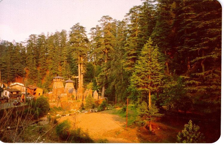
Almora. Jageshwar is a small village about 30 kms from Almora. It
is situated in a beautiful valley surrounded by mountains covered
with dense Deodar forests. Jageshwar is famous for it's Shiva Temple.
The Temple complex has 128 small and big Shivlings. We travelled to Jageshwar
by Bus. From Jageshwar we trekked to Binsar Top. Binsar Top is around
25 kms by rough estimate. From the hill top near Jageshwar,
(called Vridhh Jageshwar), one gets a lovely view of Trishul and Nanda
Devi peaks. Binsar is a sanctuary full of birds and wildlife.
the treks by trekking around Jageshwar and Binsar near
Almora. Jageshwar is a small village about 30 kms from Almora. It
is situated in a beautiful valley surrounded by mountains covered
with dense Deodar forests. Jageshwar is famous for it's Shiva Temple.
The Temple complex has 128 small and big Shivlings. We travelled to Jageshwar
by Bus. From Jageshwar we trekked to Binsar Top. Binsar Top is around
25 kms by rough estimate. From the hill top near Jageshwar,
(called Vridhh Jageshwar), one gets a lovely view of Trishul and Nanda
Devi peaks. Binsar is a sanctuary full of birds and wildlife.
Trek to Pindari
Glacier starts from Song, 32 kms from Bageshwar. One can reach Bageshwar
from Kathgodam (distance 170 kms) via Almora , or from Rishikesh (distance
380 kms) via Karnprayag . Regular buses ply from Haldwani for Bageshwar,
early in the morning. Bageshwar, at a height of 800 m above sea level,
has a KMVN rest house and few hotels. Song can be reached by travelling
along Sarju river, passing the twin township of Kapkot and Bharari on way.
Guides and porters are available at Bharari but a well charted route like
 this does not require a guide.
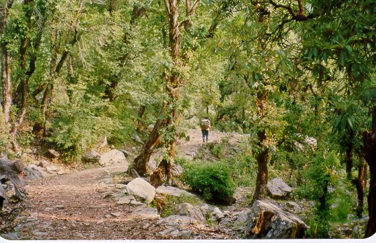
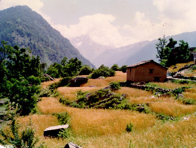
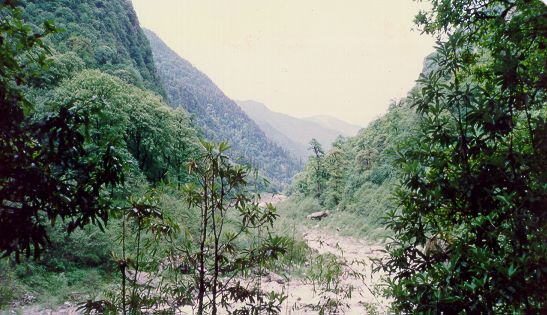
The first stop
of Pindari trek, Loharkhet is 4 kms from Song. Trekking uphill through
barren mountains, one can either halt for the night in lodges at Loharkhet
or can trek a km further to KMVN rest house. We stayed at KMVN rest
house, Loharkhet. The second day of the trek is toughest with steep climb
till Dhakuri Pass. Route passes through dense tree cover of wet subtropical
forests with a tea stall every 4 kms. An early morning start, helps in
many ways. It gives more time to cover longer stretches. By reaching the
destination before noon, one gets sufficient time for exploring the area
around. One can also avoid the afternoon downpour, typical of Himalayan
 weather. An exposure in rain results in all sort of problems.
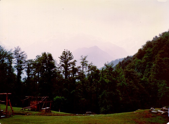
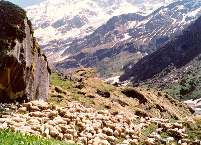
Dhakuri pass
at a height of 2800 m gives a magnificent view of Pindar valley. At this
point, the trail leaves Sarju valley to enter Pindar valley. Facing north
one gets a beautiful view of snow covered peaks Nandakot, Nandakhat, Mangtoli,
Trishul and Nandaghungti as seen from right. Down below is the KMVN rest
house, situated amidst a lush green meadow, surrounded by dense tree cover.
The panoramic view from Dhakuri pass is breathtaking and a short break
 here will be refreshing. Some people directly go to Khati but
we decided in favour of a night halt at Dhakuri Rest House. Further 10
km trek to Khati is mostly downhill.
here will be refreshing. Some people directly go to Khati but
we decided in favour of a night halt at Dhakuri Rest House. Further 10
km trek to Khati is mostly downhill.
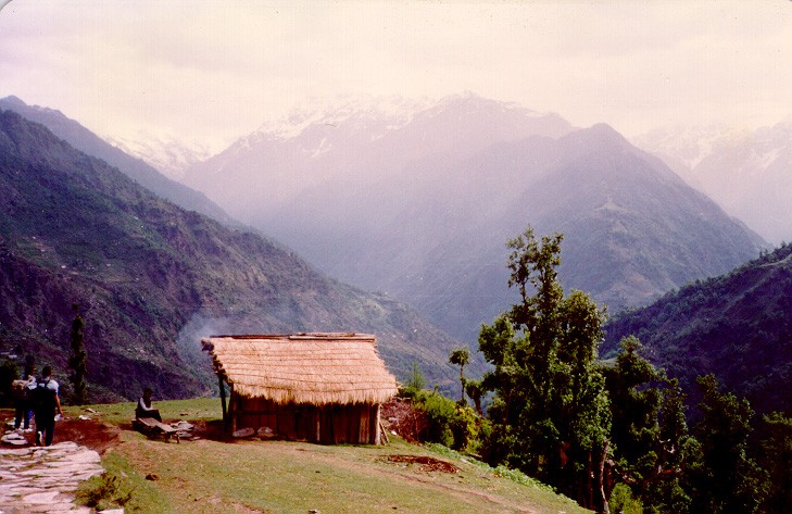
A small village
of 60 houses, Khati (2300 m) is the last point where neccessities are available.
 Here Pindar merges with Sunderdhunga river and flows west to join Alakhnanda
at Karnprayag. From Khati another trek route goes to Sunderdhunga Glacier
and Mangtoli base camp. Camping gear is neccessary for this route. After
Here Pindar merges with Sunderdhunga river and flows west to join Alakhnanda
at Karnprayag. From Khati another trek route goes to Sunderdhunga Glacier
and Mangtoli base camp. Camping gear is neccessary for this route. After
 running 16 kms parallel to Sunderdhunga river, the trail bifurcates. One
path goes to Sunderdhunga Glacier 5 kms away while another ends at the
source of Sukhram nala. Those with more determination, can try reaching
Mangtoli base Camp by crossing Sunderdhunga Glacier.
running 16 kms parallel to Sunderdhunga river, the trail bifurcates. One
path goes to Sunderdhunga Glacier 5 kms away while another ends at the
source of Sukhram nala. Those with more determination, can try reaching
Mangtoli base Camp by crossing Sunderdhunga Glacier.
From Khati
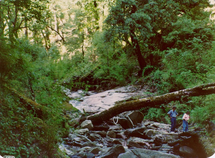 to Dwali, the trek is along Pindar river, and is surrounded by montane
type subtropical forests. Those who love the fascinating display of flowers
of many colours and descriptions should reach here by the end of June.
They will be welcomed by miraculous snowbridges and tumbling waterfalls.
Those who desire to avoid dust and haze of lower foothills should undertake
to Dwali, the trek is along Pindar river, and is surrounded by montane
type subtropical forests. Those who love the fascinating display of flowers
of many colours and descriptions should reach here by the end of June.
They will be welcomed by miraculous snowbridges and tumbling waterfalls.
Those who desire to avoid dust and haze of lower foothills should undertake
 the journey in mid-September to mid-October. KMVN and PWD rest houses at
Dwali, are situated right at the confluence of rivers Pindar and Kafni.
From here the trek bifurcates to Kafni Glacier in the east and to Pindari
Glacier in north-east.
the journey in mid-September to mid-October. KMVN and PWD rest houses at
Dwali, are situated right at the confluence of rivers Pindar and Kafni.
From here the trek bifurcates to Kafni Glacier in the east and to Pindari
Glacier in north-east.
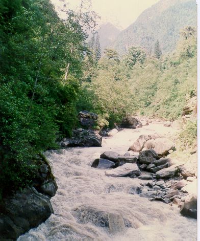
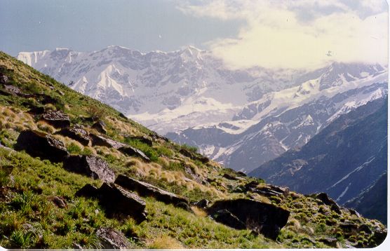
Those visiting
this area before May will find it hazardous to go beyond Dwali because
 of deep snow. The trek to Kafni glacier (12 kms from Dwali) passes through
beautiful meadows with snow covered ranges on south and barren rocky mountains
rising majestically in north. From Dwali one has to trek 8 kms to reach
Pindari Glacier before returning 3 kms back to last KMVN rest house at
Phurkia. The rarified atmosphere tires the body quickly and over exertion
could lead to mountain sickness, hence small but more frequent rest halts
of deep snow. The trek to Kafni glacier (12 kms from Dwali) passes through
beautiful meadows with snow covered ranges on south and barren rocky mountains
rising majestically in north. From Dwali one has to trek 8 kms to reach
Pindari Glacier before returning 3 kms back to last KMVN rest house at
Phurkia. The rarified atmosphere tires the body quickly and over exertion
could lead to mountain sickness, hence small but more frequent rest halts
 are advised.
Pindari Glacier
(3800 m) is about 3kms long and a quarter broad. It comes from north-west
and is joined by the Bankattia Glacier flowing from the east. Its rugged
magnificence and grandeur inspires one with wonder and awe. The zero point
provides a good view of Nandakot peak in east and Nandakhat in west. Quoting
 an article from TOI, describing two new trek routes around Pindari Glacier
- " Trekkers can take an uphill climb lasting 5 kms through a shepherd
track to reach Chhanguch kharak 16,000- 17,000 ft above sea level. Where
a beautiful lake, set in the surroundings of Nandakhat and Pindari Glaciers
awaits them. The Kharak becomes a beautiful valley of flowers after the
rains in July and August. Another route to reach Chhanguch within eight
hours after crossing the Pindar river just opposite Mangtoli. Only seasoned
an article from TOI, describing two new trek routes around Pindari Glacier
- " Trekkers can take an uphill climb lasting 5 kms through a shepherd
track to reach Chhanguch kharak 16,000- 17,000 ft above sea level. Where
a beautiful lake, set in the surroundings of Nandakhat and Pindari Glaciers
awaits them. The Kharak becomes a beautiful valley of flowers after the
rains in July and August. Another route to reach Chhanguch within eight
hours after crossing the Pindar river just opposite Mangtoli. Only seasoned
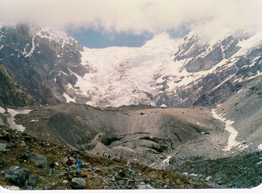 trekkers can take this route, as it is a tough task to trek a zigzag steep
climb through a shepherd trek".
trekkers can take this route, as it is a tough task to trek a zigzag steep
climb through a shepherd trek".
During summer
of 1994, trek beyond phurkia was closed because of landslides and
falling rocks. So we decided to see Kafni Glacier. There is no rest house
after Dwali so one has to cover 24 kms in a day. This is not an easy
thing at a height of
12,000 plus feet. But there are lovely camping
sites on way to Kafni Glacier. In 1994, the KMVN had started work on a
rest house 6 kms from Dwali , at a place called Khatiya. Meadows at Wyalgar,
surrounded by snow covered mountains are a good and most popular
camping ground for those on way to Kafni Glacier.
In 1994, the
lodging charges at KMVN rest houses were Rs 25/- per head and food cost
was Rs 25/- per meal.
Map of Pindari Trek
Map of Kumaon